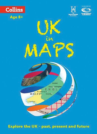
Collins Primary Atlas: UK in Maps
This product is not currently available.
To help you find what you're looking for, see similar items below.
This product has not been rated yet.
0 reviews (Add a review)

Delivery information
- FREE postage to schools*
- Postage charges apply to home addresses
- Delivery within 10 working days
Book Club orders
- FREE postage to schools*
- Books will be despatched after the school's order is confirmed
Delivery information and refund and returns policy
*We do not charge postage costs on your order, but border charges are payable and additional customs charges may be levied.
Product description
This colourful multi-topic atlas helps older children make sense of the UK using maps, diagrams, charts, statistics and photos. It’s a really complete yet simple look at how maps are used and what they can tell us about our remarkable planet. Children will learn the rules of reading atlas maps and symbols, see how different map types look, and decode aerial and satellite maps. They’ll also examine maps that reveal data about the UK’s history, environment and culture. Amazingly, comparing such maps can build a picture of the past and even help us predict the future. Includes a glossary of terms and an inspiring activity on every spread.
#sum-18-ie
Product Details
Format
Paperback
ISBN
9780007524761
Publisher
Date published
February 13th, 2014
Condition
New
UK editionReviews
This product has not been reviewed yet.
Add a review
Similar items
-

5books
Favourite Welsh Fiction 5 Book Set- eur prices
- Offer price: €50.00
- RRP: €58.73
- gbp prices
- Offer price: £34.00
- RRP: £39.95
-
6copies
Philip's Essent School Atlas (6 Copies)- eur prices
- Offer price: €71.30
- RRP: €79.29
- gbp prices
- Offer price: £48.50
- RRP: £53.94
-
DK Life Stories Florence Nightingale
- eur prices
- Offer price: €7.95
- RRP: €8.81
- gbp prices
- Offer price: £5.40
- RRP: £5.99
-
The Black Curriculum: Places
- eur prices
- Offer price: €13.25
- RRP: €14.69
- gbp prices
- Offer price: £9.00
- RRP: £9.99
-
Philip's RGS Essential School Atlas
- eur prices
- Offer price: €11.90
- RRP: €13.22
- gbp prices
- Offer price: £8.10
- RRP: £8.99
-
Horrible Histories Special: Wales (newspaper edition)
- eur prices
- Offer price: €11.90
- RRP: €13.22
- gbp prices
- Offer price: £8.10
- RRP: £8.99
-
6copies
Philip's Junior School Atlas (6 Copies)- eur prices
- Offer price: €71.30
- RRP: €79.29
- gbp prices
- Offer price: £48.50
- RRP: £53.94
-
Time Travel Twins: The Roman Invasion
- eur prices
- Offer price: €10.60
- RRP: €11.75
- gbp prices
- Offer price: £7.20
- RRP: £7.99
-
6copies
Connectors Ages 10+: Far-Flung Places (6 Copies)- eur prices
- Price: €57.33
- gbp prices
- Price: £39.00
- Not available to buy with Rewards
-
6books
Connectors Ages 11+: Human Barriers - The Walls of the World (6 Copies)- eur prices
- Price: €57.33
- gbp prices
- Price: £39.00
- Not available to buy with Rewards
-
6copies
Silence is Not an Option (6 Copies)- eur prices
- Price: €79.29
- gbp prices
- Price: £53.94
-
30copies
Philip's Junior School Atlas (30 Copies)- eur prices
- Offer price: €336.90
- RRP: €396.46
- gbp prices
- Offer price: £229.20
- RRP: £269.70


